Two million people have no water. Crops are wiped out in the northern half of the country. The worst drought in Mexico's history is likely to worsen until summer rains come devastating the northern half of Mexico, damaging Mexico's economy. Indigenous communities in rural northern Mexico have no water, no food and no crops. Communities have had no rain in 15 months. The Mexican government is mobilizing to bring food, water and jobs to the affected people.
MEXICO CITY – A drought that a government official called the most severe Mexico had ever faced has left two million people without access to water and, coupled with a cold snap, has devastated cropland in nearly half of the country.The government in the past week has authorized $2.63 billion in aid, including potable water, food, and temporary jobs for the most affected areas, rural communities in 19 of Mexico’s 31 states. But officials warned that no serious relief was expected for at least another five months, when the rainy season typically begins in earnest.
Taharuma refugees, northern Mexco, fleeing their homes.
Image may be NSFW.
Clik here to view.
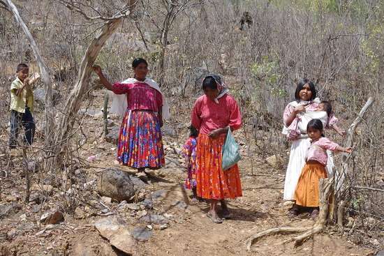
...thousands of people of the Tarahumara indigenous group, who live in the Sierra Madre range in northwest Mexico, have been coming down out of the mountains to seek food aid, because after two years of severe drought, coupled with unusual cold this winter, they are reaching their breaking point. Faced with starvation, they have become climate refugees.The Tarahumara are known in Mexico for their incredible endurance in long-distance running. They are a proud people who have held themselves aloof from modernized Mexican culture, still keeping their ancient traditions of weaving, hunting and farming. They still speak their ancestral language, and they have always been able to take care of themselves.
Until now.
In what is sure to be a trend in the coming years, it is the people who live furthest out on the margins of Empire who are affected first and most harshly by climate change.
Record extreme drought that set Texas on fire last summer also covered much of Mexico. While northern Texas got rain this fall, Mexico didn't. Northern Mexico is suffering through its second year of extreme drought. The North American drought monitor shows severe, extreme and exceptional drought affecting most of Mexico on December 31, 2011.
Image may be NSFW.
Clik here to view.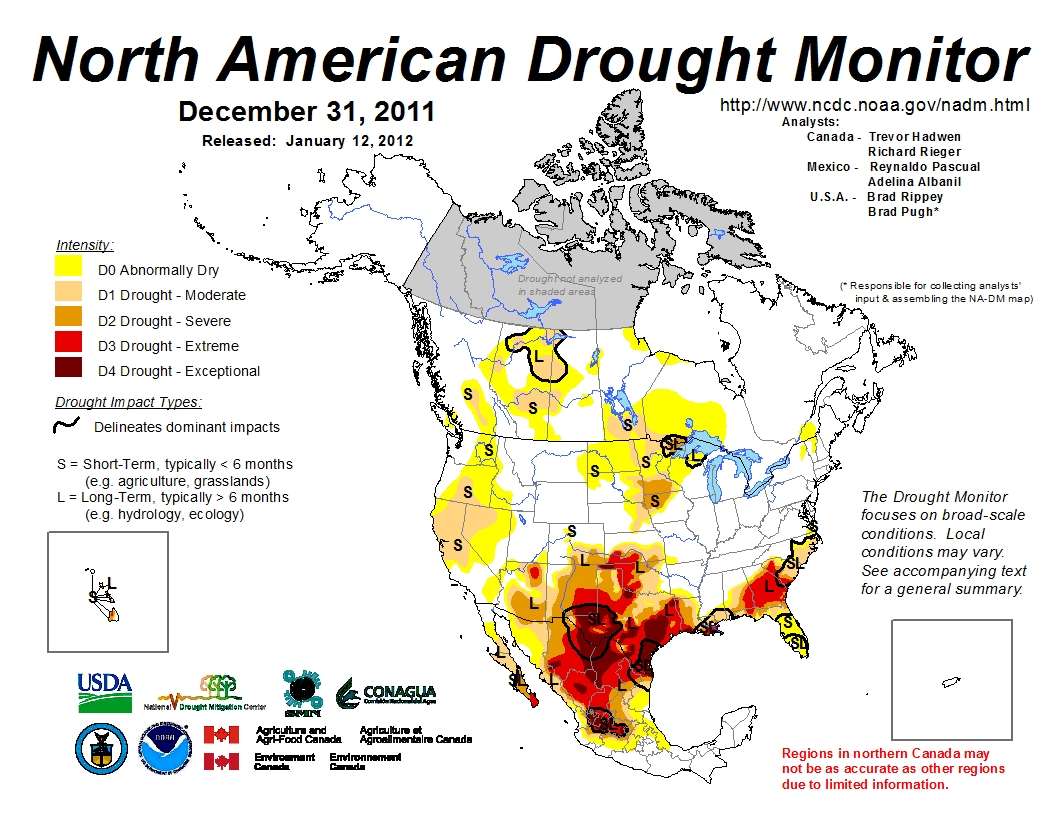
The most recent U.S. drought map issued today shows severe drought across the southern third of the United States from California to Florida and North Carolina. The southern halves of California and Georgia have been exceptionally dry this winter to date.
Image may be NSFW.
Clik here to view.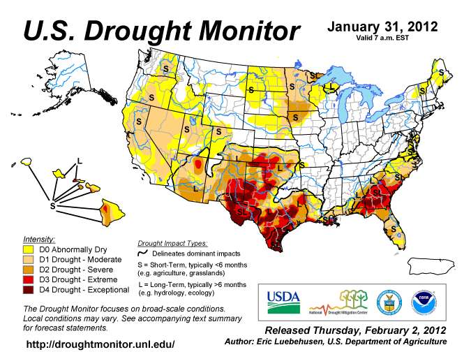
The three month drought forecast released today is as harsh as I have ever seen.
The ongoing La Niña event favors drought persistence and development for the next 3 months across the southern tier of States, from southern California eastward into Florida and northward into the Carolinas. Much of this same area will also have enhanced odds for above-normal temperatures (from Arizona and Utah eastward to the Carolinas and mid-Atlantic). Although the Northwest finally received ample precipitation during the past two weeks (usually expected in the Northwest during a La Niña), moderate drought still lingered in eastern Washington, southern Oregon, most of California and Nevada, and central Utah from a very dry start to the winter season.Unfortunately, short and medium-term forecasts maintain an upper-air ridge (high pressure) over the Far West, diverting the storms to the north and keeping decent moisture away from the region. And with another normally wet month (Feb) looking less so, the odds for significant drought improvement were lowered. Therefore, this outlook is more pessimistic toward drought recovery in northern California and Nevada, with less improvement and more persistence in these areas as compared to the Jan. 19 FMA USDO. To the south, despite early winter snowfall in Arizona and New Mexico, the odds for subnormal precipitation and above-normal temperatures across the Southwest are elevated in the monthly and seasonal outlooks. Therefore, persistence or development is forecasted across most of California, the Great Basin, Southwest, and southern Plains.
Some improvement is possible along the northern drought boundary in the central Great Plains and lower Delta with expected short-term moderate to heavy precipitation, favorable odds of above-normal February and FMA precipitation in the middle Mississippi, Ohio, and Tennessee Valleys, and persistent bouts of wet weather in this area since mid-October. Farther south and east, however, recent dryness and favorable odds of subnormal precipitation in the short and long-term maintains drought along the Gulf and southern Atlantic Coasts and expands it into the mid-Atlantic Coast. A dry (and cold) winter climatology, much below-normal precipitation (minimal snow) since the Fall, and equal odd chances (1- and 3-month outlooks) elevates the chances for persistence across the western Corn Belt and upper Midwest, with drought expansion possible in the central Dakotas.
Image may be NSFW.
Clik here to view.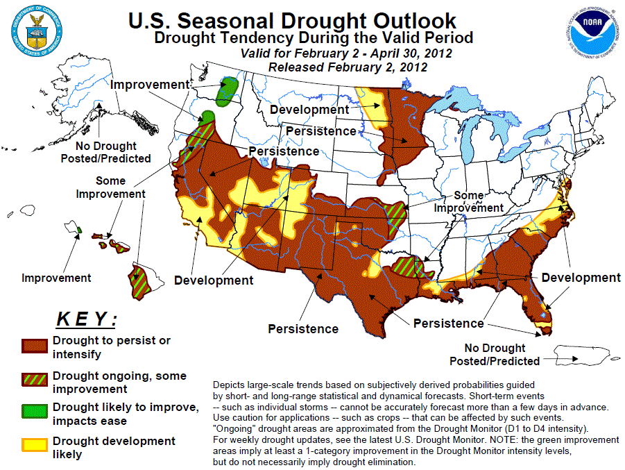
The immediate cause of the exceptional drought is the second year of La Nina
Image may be NSFW.
Clik here to view.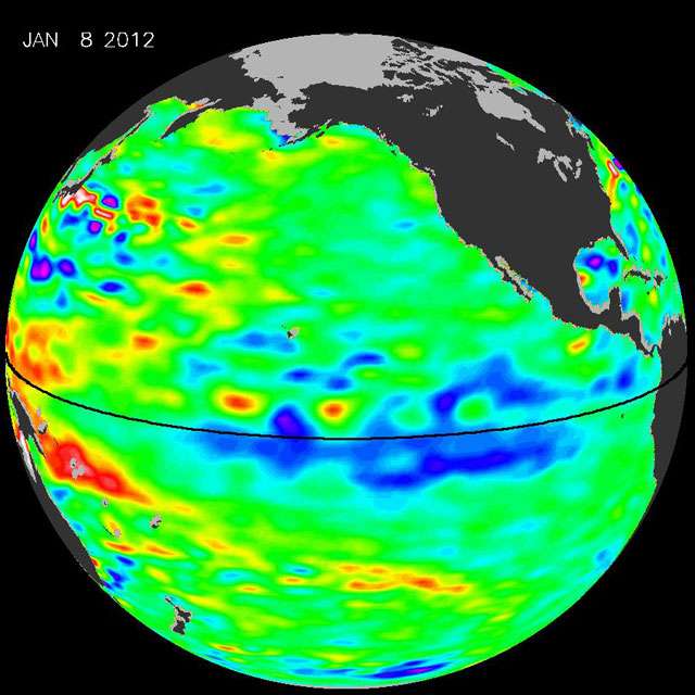
La Niña, "the diva of drought," is peaking, increasing the odds that the Pacific Northwest will have more stormy weather this winter and spring, while the southwestern and southern United States will be dry.Sea surface height data from NASA's Jason-1 and -2 satellites show that the milder repeat of last year's strong La Niña has recently intensified, as seen in this latest Jason-2 image of the Pacific Ocean.
The image is based on the average of 10 days of data centered on Jan. 8, 2012. It depicts places where the Pacific sea surface height is higher than normal (due to warm water) as yellow and red, while places where the sea surface is lower than normal (due to cool water) are shown in blues and purples. Green indicates near-normal conditions. The height of the sea surface over a given area is an indicator of ocean temperature and other factors that influence climate.
This is the second consecutive year that the Jason altimetric satellites have measured lower-than-normal sea surface heights in the equatorial Pacific and unusually high sea surface heights in the western Pacific.
"Conditions are ripe for a stormy, wet winter in the Pacific Northwest and a dry, relatively rainless winter in Southern California, the Southwest and the southern tier of the United States," says climatologist Bill Patzert of JPL. "After more than a decade of mostly dry years on the Colorado River watershed and in the American Southwest, and only two normal rain years in the past six years in Southern California, low water supplies are lurking. This La Niña could deepen the drought in the already parched Southwest and could also worsen conditions that have fueled recent deadly wildfires."
However, because there is another factor which may be making La Nina caused droughts more severe. As the climate warms the dry subtropical belts under the subtropical high pressure areas may be expanding. The expansion of the "Hadley cell" moves the storm track northward on the Pacific coast. This reduces rainfall and snowfall in Mexico, California and the southwestern United States.
Image may be NSFW.
Clik here to view.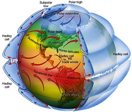
Earth's solar energy is most concentrated in the region of the equator.This heating causes warm air to rise, which creates a general area of low pressure at the equator. As the rising air cools and starts to fall back toward Earth it spreads into both the northern and southern hemispheres (see figure) and returns to the surface of Earth at approximately 30 degrees north and south of the equator. That cooled air is then drawn back towards the low-pressure area at the equator and repeats the circulation. This circulation creates what are known as the Hadley Cells.
The combination of La Nina plus climate change driven expansion of the subtropical high may be what caused this drought to be the worst in the history of Mexico and Texas.
NASA's Jim Hansen and colleagues have recently released a pre-publication report that concludes the probability was virtually nil that the drought and heat wave in Texas, Oklahoma and Mexico was the result of natural variability.
Most scientists are careful not to link specific weather events to climate change trends, but NASA's James Hansen and two colleagues from the NASA Goddard Institute for Space Studies and Columbia University have taken that plunge. They've gathered data they say shows that the 2011 Texas and Oklahoma heat wave—as well as a deadly Moscow heat in 2010—were "a consequence of global warming because their likelihood was negligible prior to the recent rapid global warming."Their conclusions are based on more than 50 years of temperature data, Hansen told InsideClimate News. By comparing the recent shift toward extreme high summer temperatures with that data, he said his group was able to demonstrate that the record-breaking 2011 Texas heat wave wouldn't have occurred without global warming.
....break..."Our paper deals with the frequency of hot seasons, mainly hot summers, because that is the most important season," Hansen said. "The times and places with hot summers tend to be where the weather is dominated ... by high pressure, so there is high correspondence between the [extremely hot outliers or extreme] heat waves and drought conditions." They also point out that summer, "when most biological productivity occurs, is the most important season for humanity and thus the season when climate change may have its biggest impact."
Dr. Hansen and colleagues use a statistical approach he calls "climate dice" to assess the probability that extreme weather events such as the Texas-Mexico heat wave are the result of human-caused climate change. He concludes that global warming has loaded the dice.
"Climate dice", describing the chance of unusually warm or cool seasons relative to climatology, have become progressively "loaded" in the past 30 years, coincident with rapid global warming. The distribution of seasonal mean temperature anomalies has shifted toward higher temperatures and the range of anomalies has increased. An important change is the emergence of a category of summertime extremely hot outliers, more than three standard deviations (σ) warmer than climatology. This hot extreme, which covered much less than 1% of Earth's surface in the period of climatology, now typically covers about 10% of the land area. We conclude that extreme heat waves, such as that in Texas and Oklahoma in 2011 and Moscow in 2010, were "caused" by global warming, because their likelihood was negligible prior to the recent rapid global warming. We discuss practical implications of this substantial, growing climate change.