NASA investigators discovered a giant crack in the Pine Island glacier in Antarctica that indicates an enormous iceberg with an area of more than 300 square miles is about to form.
Image may be NSFW.
Clik here to view.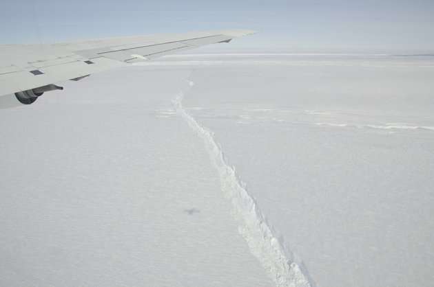
The new iceberg will have an area about ten times larger than Manhattan Island. Calving icebergs is a natural process but the Pine Island glacier just calved a large iceberg four years ago. Four years is much less than the normal return period for a new large iceberg. The huge new crack shows that the flow of the glacier is speeding up rapidly.
In just 6 years the glacier is flowing more than 6 times faster.
Recent related investigations have found that glacial flow acceleration at the coast quickly propagates to the continental interior of Antarctica. We may be witnessing the beginning of the rapid acceleration of Antarctic ice loss. The melting of this ice may accelerate the rate of sea level rise.
IceBridge measurements show Pine Island following its rapid deterioration that began around 2006.Combined IceBridge and ICESat data show the glacier is losing more than six times as much mass per year -- mass loss was measured at 7 gigatons a year in 2005 and about 46 gigatons a year in 2010 – making it one of the most significant climate change response trends that scientists see worldwide. For comparison, the Chesapeake Bay holds about 70 gigatons of water.
Image may be NSFW.
Clik here to view.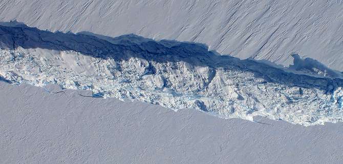
A close-up image of the crack spreading across the ice shelf of Pine Island Glacier shows the details of the boulder-like blocks of ice that fell into the rift when it split. For most of the 18-mile stretch of the crack that NASA’s DC-8 flew over on Oct. 26, 2011, it stretched about 240 feet wide, as roughly seen here. The deepest points ranged from about 165 to 190 feet, roughly equal to the top of the ice shelf down to sea level. Scientists expect the crack to propagate and the ice shelf to calve an iceberg of more than 300 square miles in the coming months. This image was captured by the Digital Mapping System (DMS) aboard the DC-8. Credit: NASA/DMS
Flow of the Pine Island Glacier is guided by the shape of the sea floor beneath the ice. Gravimeter measurements made in October 2009 revealed a deep channel leading from the Antarctic coast to Pine Island Bay. (Image by Jesse Allen, using data from Michael Studinger, NASA GSFC and Columbia University.)
Image may be NSFW.
Clik here to view.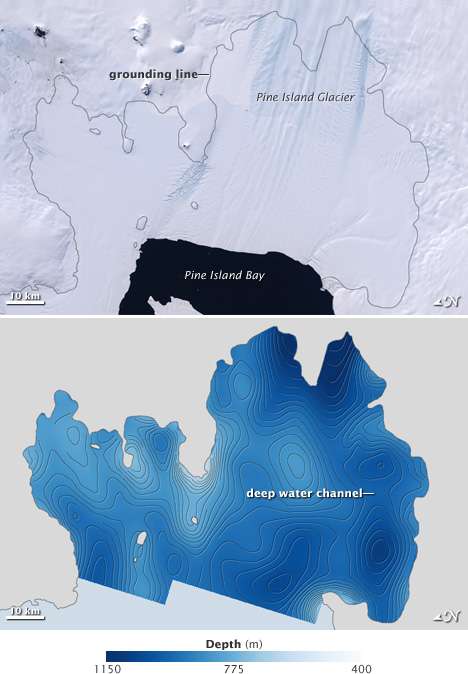
NASA discovered that the glacier is being rapidly melted and broken up by warm water flowing in from below the ice. Gravity measurements showed linear area of low gravity, an indication of a deep water channel under the ice.
“The bathymetry explains right away why Pine Island Glacier is melting,” says Studinger. A deep channel snakes from the front of the glacier to the grounding line, where the land connects to the ice and holds it in place. Warm water has been reaching the grounding line and undercutting the glacier, forcing it to move and melt quickly.“When we put this data into the ocean circulation models, they suddenly made sense,” says Studinger. “The melt rates that they produce are very close or almost identical to the melt rates that we are observing.”
Because other major Antarctic outlet glaciers are "grounded" below sea level they, too are subject to the effects of warm ocean water. They, too, are likely to suffer a rapid increase in melting, flow and break up. As I reported in August, the instability of Antarctic glaciers to the effects of warming oceans has profound consequences.
Old theories of Antarctic ice stability, proven wrong today by a report in Science, incorrectly disconnected ice flow in the deep interior from ice flow near the coast. Therefore, they probably significantly overestimated the stability of Antarctic ice.Today's report in Science ties in with a NASA report in July in the journal of Glaciology which found rapid acceleration of ice loss in the coastal zone took place after the break up of the Larsen B ice shelf on the Antarctic peninsula. Warm sea water, likely caused by effects of global warming, melted the ice shelf melted from below then calved the huge Larsen B iceberg and set the large coastal glacier behind it in motion. When the ice shelf broke lose it was like a dam burst that rapidly accelerated glacial flow in the coastal region. Taken together, the results of these two reports are profound. Once a dam of ice grounded at the coastal outlet is broken by warm ocean water, glacial flow may accelerate into the continental interior through a network of glaciers.
Please join me tomorrow, Sunday at 2pm in Washington, DC for Tar Sands Action. If you can't be in DC, the link has a list of other actions you can take to stop the XL Pipeline.